
East Honolulu ZIP Coverage
Three ZIP Code Tabulation Areas are fully or partly tied to East Honolulu CDP: 96816, 96821, and 96825. Each reaches across local or statistical lines. USPS uses Honolulu as the postal city for all three, so the city on an envelope does not identify the exact community.
| ZIP | East Honolulu Areas | Postal City | Boundary Note |
|---|---|---|---|
| 96816 | Western and Waiʻalae-side overlap | Honolulu | Extends into Urban Honolulu areas |
| 96821 | ʻĀina Haina, Kuliʻouʻou, Kalani Iki, Waiʻalae Iki | Honolulu | Also overlaps Urban Honolulu |
| 96825 | Hawaiʻi Kai, Portlock, Hahaʻione, Kalama Valley, Koko Head, Mariner's Ridge | Honolulu | Tied closely to Maunalua |
Keep 96795 separate. It is linked with Waimānalo in the broader planning context, but is not part of the core CDP list without an address-level explanation. No PO-box-only or unique institutional ZIP was documented for East Honolulu.
East Honolulu ZIP 96816
ZIP 96816 is the western overlap in the East Honolulu ZIP code directory. It meets the Waiʻalae side and serves places that Census or local planning sources may place in Urban Honolulu. This is the clearest case where a ZIP search reaches beyond the CDP.
Retain the full street and house number. Compare it with Census TIGERweb geography or a parcel layer. Do not replace the postal city merely to force a neighborhood label.
Note: ZIP 96816 narrows the western search area, but only an address-level check can place a record inside East Honolulu CDP.
East Honolulu ZIP 96821
ZIP 96821 serves much of the ʻĀina Haina, Kuliʻouʻou, Kalani Iki, and Waiʻalae Iki side. Aina Haina Public Library is a useful public access point, with computers, newspapers, magazines, Wi-Fi, and meeting space. The library confirms civic geography without acting as a people roster.
The ZIP overlaps areas beyond a strict East Honolulu CDP reading. Preserve ʻokina and kahakō when a source uses them, and keep the address as printed. A normalized form can sit beside the original but should not replace it.
East Honolulu ZIP 96825
ZIP 96825 is closely linked with Hawaiʻi Kai, Portlock, Hahaʻione, Kalama Valley, Koko Head, Mariner's Ridge, and Maunalua. Hawaii Kai Public Library and the Hawaiʻi Kai Satellite City Hall are official local reference points. The mailing city stays Honolulu.
Modern street and parcel patterns reflect the postwar change from Kuapa Fishpond to Hawaiʻi Kai Marina. Old maps, deeds, and directories may use Maunalua or broad Honolulu labels instead of current development names. The ZIP is a modern postal key, not a timeless boundary.
Official East Honolulu ZIP Tools
No one tool answers every geographic question. Use USPS city and state lookup for ZIPs recognized for Honolulu, and USPS exact-address lookup for one known address. Neither is a bulk people search. Census and parcel tools serve different aims.
| Mode | Fields or Output | Limit |
|---|---|---|
| USPS city/state | City, state, ZIP set | Postal recognition, not a CDP polygon |
| USPS address | Full address and delivery result | One address, not a resident list |
| Census geography | CDP and ZCTA relationship | ZCTA approximates delivery geography |
| Street range | Road, house range, ZIP | Dated finding aid; ranges can change |
| Parcel address | Situs, TMK, mapped parcel | Postal and physical keys can differ |
The Census East Honolulu listing was captured for this ZIP code directory.
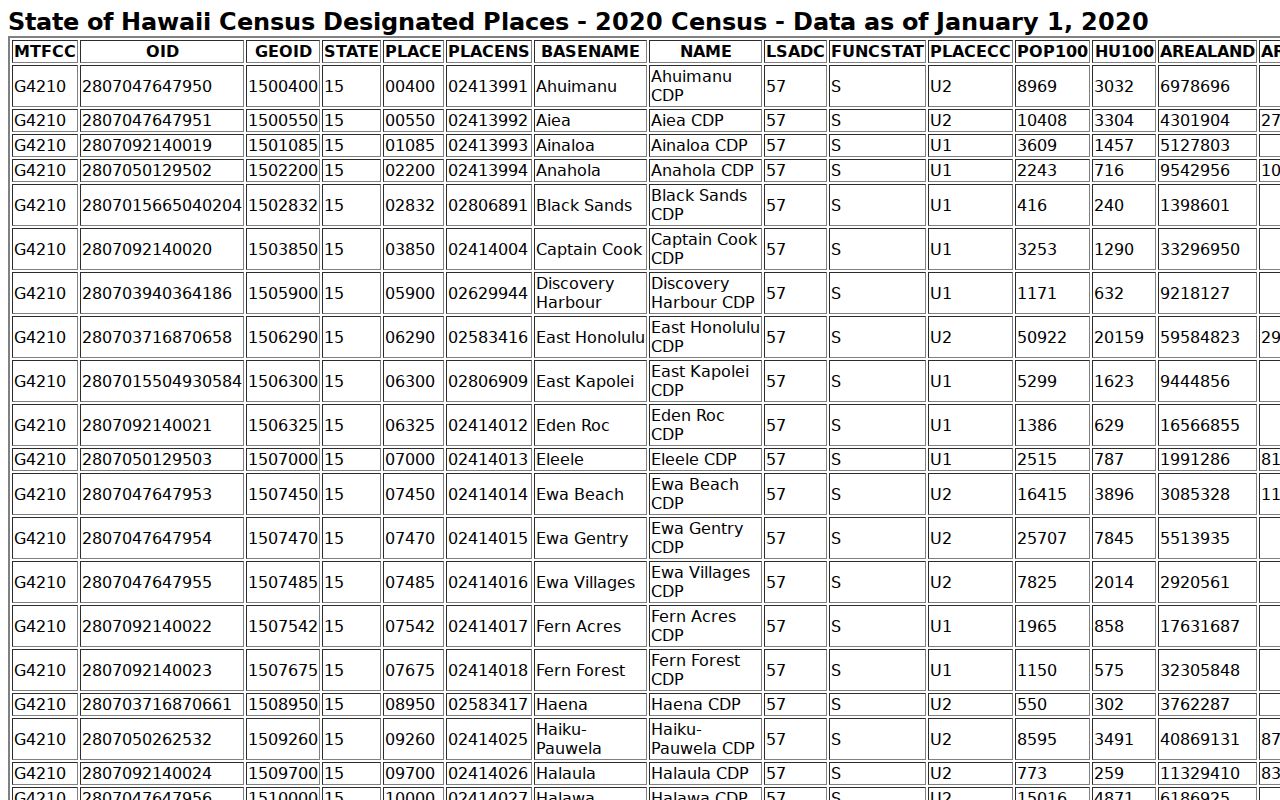
The image grounds the postal discussion in official CDP geography and shows why a Census place and mailing ZIP must stay separate.
Search East Honolulu by ZIP
A ZIP code should narrow an address record, not produce a list of people. Honolulu's street index connects road ranges to postal areas. DPP, assessment, and GIS sources then link a full situs address, meaning the physical parcel address, to a TMK.
- Verify a known address in the USPS exact-address lookup and save the ZIP as returned.
- Check the road and house range in the Honolulu street index.
- Use Honolulu GIS or DPP to confirm the physical address, parcel, and TMK.
- Compare the point with Census CDP or ZCTA geography and name the boundary used.
- Save the source date because street ranges and portal data can change.
DPP accepts a house-number prefix, remainder, suffix, and street name without type, or an eight-digit TMK. Legacy data ends July 28, 2025, while newer permit data moved toward HNL Build. The East Honolulu street directory covers the next address-level steps.
Honolulu Labels in ZIP Records
USPS uses Honolulu even when residents use Hawaiʻi Kai, ʻĀina Haina, Kuliʻouʻou, Portlock, or Maunalua in speech and civic records. Postal city names guide delivery. Neighborhood names add local context.
Store the ZIP as returned, postal city, address as printed, source date, and boundary note. Add a board district, planning area, Census place, or parcel only when an official source supports it. This keeps one familiar label from replacing another.
Note: A Honolulu postal line can be correct while the address belongs to a distinct East Honolulu neighborhood and board area.
Record East Honolulu ZIP Evidence
A useful ZIP code directory result includes more than five digits. Save the exact query, the tool, the result date, and the geographic claim being tested. If USPS confirms delivery but Census TIGERweb places the point outside the CDP, both results can be correct. They describe different systems. The same rule applies when a neighborhood-board map and a DPP planning area place one street in different named regions.
Long roads make careful notes essential. Kalanianaʻole Highway is the main corridor through East Honolulu, and the official street index shows why a road name alone cannot settle a ZIP or neighborhood. Hawaii Kai Drive, Maunaloa Avenue, and Maunalua Avenue also require their house-number range and source date. Spelling matters because Maunaloa and Maunalua are not interchangeable names.
| Saved Field | Why Keep It |
|---|---|
| ZIP as returned | Preserves the postal tool's answer |
| Full printed address | Keeps number, suffix, street, and unit context |
| TMK or parcel UID | Connects the address to mapped land |
| Boundary type | Names CDP, ZCTA, board, planning area, or parcel |
| Source and date | Lets a later reader check a changed range or portal |
Do not infer that every name tied to a mailing address is a current resident. Property systems may show an owner or lessee, while the mailing address may differ from the physical site. Election records expose only a narrow public field set under Hawaii law. ZIP geography narrows the next search; it does not turn those sources into a household list.
East Honolulu ZIP Boundary Layers
East Honolulu has no incorporated city limit. The Census CDP is a statistical boundary with GEOID 1506290. The city planning area is broader, reaching from Makapuʻu Point toward Waiʻalae Nui. Neighborhood boards, postal routes, and parcel edges use still other lines.
- ZIP versus ZIP+4
- A five-digit delivery area versus an add-on for a more precise delivery segment.
- PO-box ZIP
- A code mainly or solely assigned to post-office boxes; none was documented here.
- Unique ZIP
- A code assigned to one major organization; none was documented here.
- Carrier route
- A delivery path within a ZIP, not a civic or Census boundary.
The 2020 Census count of 50,922 refers to the CDP, not all addresses in the three ZIPs. DPP neighborhood totals use other boundaries and cannot be substituted.